
Sightings data explained: Protocols for location names and grid references
Below is an explanation of how locations are described and grid references determined for Manx BirdLife's automated sightings system.
Back to 'Submit your sightings' >>
'Nearest grid reference' principle
Location names and grid references are provided in a form that caters for non-specialist users:
Location names do not assume you have any knowledge of the Isle of Man’s geography or administration. For example, it is not taken for granted that you will know Parish names and boundaries. Hence location names are prosaic and descriptive to help you locate them quickly in terms of commonly available maps and road atlases.
We suggest that the Ordnance Survey Isle of Man (95) 1:50,000 scale map will suffice for most uses. However, the Isle of Man Survey’s own Outdoor Leisure 1:25,000 Maps (North and South editions) are excellent in their detail and local annotations.
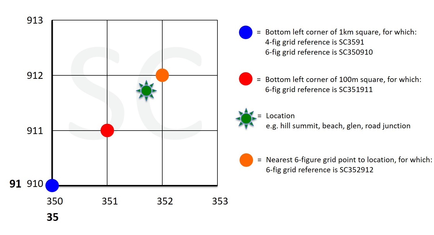
Six-figure grid references define a 100m square area using that square’s bottom left (south west) corner as its coordinate. [Likewise, a four-figure grid reference defines a 1km square and an eight-figure grid reference defines a 1m square, similarly using the bottom left (south west) corner of each square as its coordinate.]
While 1km and 1m squares are useful for many reasons, six-figure grid references are most commonly used for everyday mapping purposes. (1km square is of course too big an area to provide useful directions to a specific location, while 1m is so small that it is impractical for most purposes.)
The six-figure grid reference given for each location in the Manx BirdLife sightings system is that which is closest to the location, not that which refers to the 100m square in which the location is found. (See image below, in which the green location is nearest to the orange grid point, though it sits within the square that is defined by the red grid point. For this green location, as in the Manx BirdLife sightings system, the orange grid point is used to give the nearest six-figure grid reference (i.e. nearest coordinate).
Grid reference and location name protocols
In trying to provide a consistent and common-sense approach, we have followed these guidelines wherever possible:
- Any six-figure grid reference can be duplicated (i.e. appear in the listing more than once), as any one location might be known by different names. In most cases we have included the alternative name for a location within the one label. Where this is not practicable (e.g. where there are several alternative names or spellings), we have repeated the grid reference with the alternative name(s).
- Each location name and description is unique in order to ensure its identifies exactly which site it is. For example, the name 'Ballabeg' is commonly used, so the location name will uniquely identify to which 'Ballabeg' the grid reference refers.
- Six-figure grid references represent the nearest grid reference to a location (not the pertaining 100m grid square), as explained above.
- Wherever possible, juxtaposition is described as, for example, 'north of' or 'south of' in order to be specific, rather than simply stating 'near' or 'adjacent to', which is ambiguous.
- As a rule, Manx language/alternative location names are placed in brackets after the commonly used name. There are exceptions to this, for example where the Manx name is the most commonly used or only name for a location.
- A location is a physical place or feature. Where that place or feature has no known name, it is described in terms of its juxtaposition to other known named places or features – for example, “slope north of …” or “woodland southeast of …”.
- Abbreviations have been avoided in order to make searching the location list easier. One exception is the use of “St’ as the abbreviation for “Saint” or “St.”
Recommended resources
Of the many resources available, we have found the following to be most useful:
Maps
- Ordnance Survey Isle of Man (95) 1:50,000 scale map – will suffice for most uses
- Isle of Man Survey’s Outdoor Leisure 1:25,000 Maps (North and South editions) – excellent in their detail, local annotations and use of Manx names
Online
- www.gridreferencefinder.com - intuitive tool for entering and determining grid references and other coordinate formats.
NB. Be aware that on:
- Entering a grid reference, the displayed pointer will be positioned at the bottom left of the defined grid square
- On right-clicking to find a grid reference, the displayed pointer will give coordinates for the bottom left of the grid square in which the location you clicked on sits, not necessarily the nearest grid reference. If you then re-enter the given grid reference, you will find that the displayed pointer moves (now being positioned at the bottom left of the defined grid square)! Hence care is needed to ensure you know the difference between the nearest grid reference and the grid reference of the pertaining grid square.
- www.streetmap.co.uk - online version of the Ordnance Survey maps with some useful features.
NB. Unlike www.gridreferencefinder.com, on:
- Entering a grid reference, the displayed pointer will be positioned at the centre of the defined grid square! This inconsistency between mapping tools is another reason to check your understanding of what grid reference is being given to you by such tools!